


Perry-area residents should brace themselves for dangerous winter travel conditions early this week as icing is expected over much of central Iowa Monday and Tuesday.
The Sunday night storm front will be preceded Sunday afternoon by high winds, and the National Weather Service (NWS) office in Des Moines has issued a wind advisory until 2 p.m. Sunday for the and the northwest half of Iowa.


Sustained winds of 30 mph, with gusts of 45 mph or higher, are expected through the early
afternoon and diminishing by mid-afternoon. The strong gusts will make driving difficult, especially on east-west roads and for high-profile vehicles.

Travelers are urged to use extra caution.
After Sunday’s warm and windy afternoon, a cold front will push into the state Sunday night, with much colder air spreading across the northwest half of Iowa.
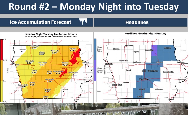
The NWS office in Des Moines has issued a winter storm watch from 6 p.m. Monday until noon Tuesday.
Freezing drizzle and light freezing rain will develop across portions of western and northern Iowa overnight and persist into Monday, with icing of one-tenth of an inch in many locations.
The ice will produce hazardous travel conditions and make for a difficult commute on Monday morning for much of the northwest one-third of Iowa.
Temperatures ahead of the front will be in the 30s and 40s, with light rain developing late Sunday night, but temperatures behind the cold front are forecast to drop into the teens and 20s late Sunday night and into Monday morning.
A second round of freezing rain is expected to spread into central Iowa on Monday and persist into Tuesday before ending.
Icing is expected to be heavier with this round, with glazing approaching one-quarter inch from central Iowa near the Des Moines metro area into northeast Iowa, including the Waterloo area.
The area most likely to see the heaviest ice accumulations is a swath from south central up into northeast Iowa.
Some light snow is expected in northwest Iowa, with rain in the southeast.
The icy conditions will make travel dangerous and nearly impossible, especially on untreated roads, and a very hazardous Tuesday morning commute is expected over much of central Iowa.
Power outages and tree damage are possible due to the accumulated ice.
Along with Perry and all of Dallas County, Iowa counties under the winter storm watch include Butler, Bremer, Hardin, Grundy, Black Hawk, Story, Marshall, Tama, Polk, Jasper, Poweshiek, Madison, Warren, Marion, Union, Clarke, Lucas, Ringgold and Decatur counties.
Iowa cities under the winter storm watch include Parkersburg, Clarksville, Shell Rock, Greene, Aplington, Allison, Dumont, Waverly, Iowa Falls, Eldora, Ackley, Grundy Center, Reinbeck, Conrad, Dike, Wellsburg, Waterloo, Cedar Falls, Ames, Marshalltown, Tama, Toledo, Traer, Dysart, Gladbrook, Waukee, Adel, Des Moines, Newton, Grinnell, Winterset, Earlham, Indianola, Norwalk, Carlisle, Pella, Knoxville, Creston, Osceola, Chariton, Mount Ayr, Lamoni and Leon.
The latest road conditions can be obtained by calling 5 1 1.
ThePerryNews.com will update this weather forecast as information becomes available.


