


 The National Weather Service (NWS) office in Des Moines has issued a winter storm watch for the Perry area from 6 a.m. Tuesday until midnight Wednesday.
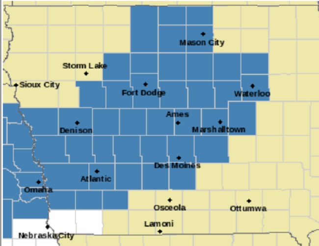
Heavy mixed precipitation possible, with total snow accumulations of 4 to 8 inches and ice accumulations of one-tenth of an inch possible across much of Iowa. The area of greatest snowfall is expected along and north of U.S. Interstate 80, with the greatest ice hazard
along and south of U.S. Interstate 80.


The winter storm will begin to affect the region Tuesday morning, according to NWS forecasts, and bring with it widespread snowfall and likely periods of wintry mix, including freezing rain that will make travel difficult.
Accumulating snowfall will be greatest north of U.S. Interstate 80, with a potentially tight gradient near the interstate. Any ice accumulations from freezing rain and sleet will also
further deteriorate travel conditions and will be most likely near and south of U.S. Interstate 80 during the day and further northward overnight.
The NWS said the greatest uncertainties in the forecast involve the southern edge of the heaviest snowfall and the total icing potential, and both include the U.S. Interstate 80 corridor at this time. Regardless, there is high confidence in this winter storm causing widespread travel hazards across most of the area. Travel could be extremely difficult, and it appears likely that both the morning and evening commutes Tuesday will be difficult.
Along with Dallas County, the Iowa counties included in the winter storm watch include Kossuth, Winnebago, Worth, Hancock, Cerro Gordo, Pocahontas, Humboldt, Wright, Franklin, Butler, Bremer, Sac, Calhoun, Webster, Hamilton, Hardin, Grundy, Black Hawk, Crawford, Carroll, Greene, Boone, Story, Marshall, Tama, Audubon, Guthrie, Polk, Jasper, Cass. Adair, Madison, Warren and Adams.
Along with Perry, the winter storm watch includes the cities of Algona, Forest City, Lake Mills, Northwood, Manly, Garner, Britt, Kanawha, Mason City, Clear Lake, Pocahontas, Laurens, Rolfe, Fonda, Gilmore City, Humboldt, Eagle Grove, Clarion, Belmond, Hampton, Parkersburg, Clarksville, Shell Rock, Greene, Aplington, Allison, Dumont, Waverly, Sac City, Lake View, Odebolt, Wall Lake, Schaller, Early, Rockwell City, Manson, Lake City, Pomeroy, Fort Dodge, Webster City, Iowa Falls, Eldora, Ackley, Grundy Center, Reinbeck, Conrad, Dike, Wellsburg, Waterloo, Cedar Falls, Denison, Carroll, Jefferson, Boone, Ames, Marshalltown, Tama, Toledo, Traer, Dysart, Gladbrook, Audubon, Exira, Guthrie Center,
Panora, Bayard, Casey, Waukee, Adel, Des Moines, Newton, Atlantic, Greenfield, Stuart, Adair, Fontanelle, Winterset, Earlham, Indianola, Norwalk, Carlisle and Corning.
ThePerryNews.com will update this weather story as forecasts evolve.


