With the Dallas County Conservation Board’s connector-trail project from Perry to Woodward set to begin construction in the spring of the portion running westward from the Woodward city limits, the Woodward City Council is looking to build its crosstown leg from the High Trestle Trail trailhead to the county trail.
Toward this goal, the council approved four resolutions at Monday night’s meeting for in-town land acquisition and additional engineering services, but the city will forgo its preferred route due to a property owner’s high asking price.
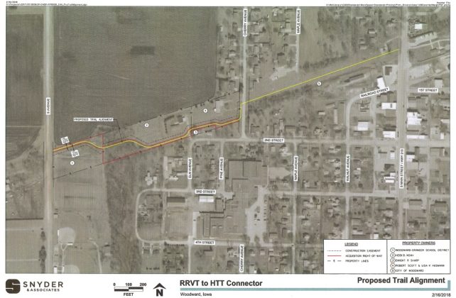
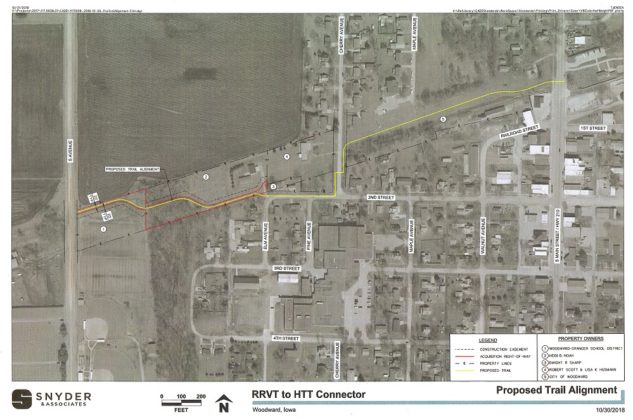
The preferred route would run southwestward from the trailhead along the abandoned railbed until it crossed Cherry Avenue and then southward and southwestward inside the property line of Robert and Lisa Husmann at 98 N. Cherry Ave.
“However, we have reached an impasse due to purchase price,” Connector Trail Committee Chair Craig DeHoet told the Woodward City Council. He said the city is using Resource Protection and Enhancement (REAP) grant funds secured in 2014 to buy land for the trail, and the Iowa Department of Natural Resources (DNR), which administers REAP grants, prohibits paying more than fair market value for recreational-trail land acquisition.
“We had a hiccup with our plan,” DeHoet said, “because each piece of property that we try to get approval for, we have to have assessed by the DNR for value because they don’t want us to expend more funds for a property other than market value. Somebody can’t take advantage of the city and taxpayers and ask for a lot more money than what the property’s worth.”
DeHoet said the city made a fair-market offer to the Husmanns of $6,200 for the 7,313 square feet needed to build the 10-foot-wide path along the edge of their property, but the Husmanns countered with an ask of $40,000, including $30,000 for the land and an additional $10,000 for their loss of privacy.
“Considering that the property owner’s request is so far from the offer, we prefer to use an alternative route,” DeHoet said.
The trail’s revised route will run southward along the Cherry Avenue right of way and then westward along the Second Street right of way until Second Street turns southward. The path would then enter the property of Heidi B. Noah at 502 W. Second St., who agreed to sell land to build the trail for $14,400.
Tim Piper and Melissa Piper of 201 Pine Ave. raised objections to the revised route for reasons of cost and safety.
“I want the city to understand that I live right there on that corner,” Tim Piper said. “The added cost of having that bike trail run down through the street there is probably going to be more than just buying that (Husmann) property because you’re going to have to do something with that corner of that road in order to make it feasible or somebody will die there. The traffic that comes around there on a daily basis will kill somebody.”
Melissa Piper agreed Second Street would be dangerous for a bike trail.
“The amount of buses and semis and teenagers that are on that street every day,” she said, “I don’t see more than two cars on any day stop at the stop sign, let along the speed they’re hauling down that street.”
DeHoet said the revised route is still provisional.
“Our plan is not to use Second Street,” he said, “but it’s what we have to go with right now. That’s what the plan is the way it sets right now. That doesn’t mean that’s where we’re going to end up.”
He said the DNR wants to see a definite route proposed for a project in order for the project to qualify for further grant funding.
“We have to move forward with this so we can get into the next grant cycle,” DeHoet said. “For planning purposes, we have to have a path on the map, and that’s what we have to use for right now to move forward.”
From Noah’s ground the trail will continue westward across Woodward-Granger Community School District property until it reaches the city limits at S Avenue. The school district will cede ownership of land for the trail at no cost, a custom between public entities.
Monday night’s trail-related resolutions included the council’s approval of spending $15,000 of the REAP funds for further engineering and design work by Snyder and Associates, approval of the purchase of the Noah property for $14,400 and approval of acquiring both the school district ground and a temporary construction easement from the school.
With only three members present, the bare bones council unanimously approved the resolutions.


